
News +++ News +++ News +++ News +++ News
Map of the month July 2024: World Population Day
On the occasion of World Population Day, which takes place on 11 July, we take a statistical look at the population development of the Centrope region in the last two decades. Remarkable population loss can be seen in the Southern Hungarian part of Centrope as well as in the Northern and South-Western districts of Lower Austria. An overall population gain can be noticed in the Vienna-Bratislava region and in/around Brno, České Budějovice and Győr. The map is available through our geoportal map.centropemap.org.
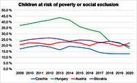
Chart of the month June
On the occasion of International Children's Day we take a look at children at risk of poverty or social exclusion. This indicator is defined as the sum of children (0-17) who are at-risk-of-poverty or severely materially deprived or living in (quasi-)jobless households (i.e. households with very low work intensity (below 20 %) as a share of the total population in the same age group. While the numbers are constant or slowloy decreasing in the Czech Republic, Austria, and Slovakia, we can see a significant decline in Hungary. Data source: ec.europa.eu/eurostat/databrowser/view/tespm040/default/table
Did you know?
These are the names of the four Centrope coutries in their respective languages (and English):
| English | Austria | Czechia | Hungary | Slovakia |
| Czech | Rakousko | Česko | Maďarsko | Slovensko |
| German | Österreich | Tschechien | Ungarn | Slowakei |
| Hungarian | Ausztria | Csehország | Magyarország | Szlovákia |
| Slovak | Rakúsko | Česko | Maďarsko | Slovensko |
Overview
![[Translate to Magyarul:] The centrope region](fileadmin/_processed_/8/c/csm_centroperegion_092d49382d.png "[Translate to Magyarul:] Centrope region")
![[Translate to Magyarul:] CentropeMAP screenshot](fileadmin/_processed_/b/8/csm_cmap_46e6042f38.png "[Translate to Magyarul:] CentropeMAP")
![[Translate to Magyarul:] CentropeSTATISTICS screenshot](fileadmin/_processed_/a/1/csm_cstat_3e02e94659.png "[Translate to Magyarul:] CentropeSTATISTICS")
CentropeMAP/STATISTICS is a cross-border information system and free geoportal of the Austrian Planning Association East (PGO) which gives planners, decision makers, researchers, teachers, students and everyone else interested a better overview of the Centrope region.
CentropeMAP is a geoportal connecting the region by collecting web map services from the partner countries. The services are brought together in a single map viewer and allow the user to experience a cross-border working area with dozens of data layers dealing with all topics which could be of interest for regional planners and similar professions. Layers are coming from the fields of biota, boundaries, elevation, imagery/base maps, inland waters, planning/cadastre, structure, and transportation.
CentropeSTATISTICS is the only available free web tool to visualise cross-border statistical data in its own connected geoportal allowing the user to influence the way of visualisation in multiple ways in the Centrope region. CentropeSTATISTICS can not only create maps, it also serves charts which are interactively created from the data in the cross-border database. For the Czech Republic, CentropeSTATISTICS does not only cover the Centrope county Jihomoravský, but also features data from the counties Vysočina and Jihočesky which are also adjacent or close to the Austrian border.
CentropeMAP and CentropeSTATISTICS Info Folder
- Download of German version (PDF, 3 MB)