
Map of the month November 2026: All Saint’s Day
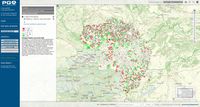
November 1st is All Saint’s Day. Many people go to the cemetery around this day to remember their deceased family members and friends. Therefore, we take a look at the change of death rates in the Centrope region, comparing the change in deaths per 1,000 inhabitants. The map shows a comparison of 2014 and 2024. The fact that there are more variations in certain areas is due to the smaller municipalities found there. Overall, however, these differences are in line with those in the other sub-regions, so there is obviously no spatial correlation with the change in death rates over time. The map is available through our geoportal map.centropemap.org
Map of the month October 2026: World Cities Day
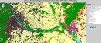
In 1900, there were 1.6 billion people on Earth; today, that number has already reached 7 billion. Of these, 54 percent currently live in cities. By 2030, the number of city dwellers is expected to reach 5 billion. However, this so-called urbanization also brings its own set of problems. Cities offer opportunities for sustainable development, but at the same time, they are also risky places to live. 31 October is World Cities Day. On this occasion we are taking a look at the land us in urban agglomerations comparing the European Urban Atlas from 2006 and 2018.
Open Map for Vienna-Bratislava region

Map of the month August 2026: International Day of Youth
International Youth Day 2026, celebrated on 12 August, recognises that while young people’s lives are shaped by different national and local realities, their aspirations are remarkably similar. Across countries and communities, young people seek dignity, opportunity, meaningful participation, decent work, quality education, and a sustainable future. On this occasion we are taking a look on the development of the youth ratio of Centrope's population from 2014 to 2024. The maps show an overall decrease of the youth ratio, which is not only a sign of decreasing birth rates in the past, but also a result of the growing ratio of older population.
Open Map for Vienna-Bratislava region
Open Map for Eisenstadt-Győr region

Map of the month June 2026: International Day of Parents
1 June is the International Day of Parents. On this occasion, we are taking a look at the development of the birth rate (live births per 1,000 inhabitants) in the Centrope region. The slider maps compare the years 2013 and 2023. In average, the numbers are lower for 2023 throughout the whole region. This could simply be a classic statistical outlier, as the lockdowns during the coronavirus pandemic led to a temporary rise in the birth rate, which in the following years caused saturation effects resulting in lower numbers of births.
Open Map for Vienna-Bratislava region
Open Map for Seewinkel-Győr region
Map of the month April 2026: Tree cover density
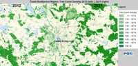
Tree cover density impacts ecosystems and urban areas by regulating temperature, improving air quality, enhancing biodiversity, and reducing noise. Higher density typically enhances environmental benefits, such as lowering urban heat, but excessive density in specific biomes can hinder biodiversity and increase vulnerability to storm destruction. The slider maps compare the years 2012 and 2021.
Open Map for Vienna-Bratislava region
Open Map for Győr-Neusiedl region

Map of the month February 2026: Old age dependency ratio
The old-age dependency ratio measures the number of elderly people (aged 65+) per 100 individuals of working age (15-64), highlighting the demographic burden on the workforce. The numbers show an increase from 2014 to 2024 throughout the whole Centrope region, which is a significant indicator for the ageing of the whole population, despite having a higher ratio of younger people in Slovakia, for example. All exact numbers and time series data from 2008 to 2024 can be retrieved from our cross-border database on municipality level.
Open Map for Vienna-Bratislava region

Map of the month December 2025: World Soil Day
World Soil Day is an international day of action on 5 December. It was designated by the International Union of Soil Sciences (IUSS) at its 17th World Congress in Bangkok in August 2002. On this occasion, we are taking a look at the development of imperviousness in the Centrope region, comparing data from 2006 and 2018. Slider maps are available for the surroundings of the larger cities in the region:
Open Map for Vienna-Bratislava region

Map of the month October 2025: International Day of Older Persons
International Day of Older Persons takes place annually on 1 October and was established by the United Nations General Assembly in 1990. It aims to draw attention to the challenges and needs of older persons, combat age discrimination and promote intergenerational solidarity. On this occasion we take a look at the development of older population (aged >65) over time in the Centrope region. The comparison shows data from 2012 and 2022. Slider maps are available for the surroundings of the larger cities in the region:
Open Map for Vienna-Bratislava region

Map of the month August 2025: World Lake Day
On the occasion of World Lake Day, which takes place on 27 August, we take a look at water bodies and water courses in the Centrope region. The comparison shows Corine Land Cover data from 2000 and 2018. The 2018 layer also shows the built-up area 2000–2014 from the Global Human Settlement Layer. Slider maps are available for the surroundings of the larger cities in the region:
Open Map for Bratislava region

Map of the month June 2025: Imperviousness Comparison 2009 – 2018
On the occasion of World Environment Day (5 June) we are going to take a look at the changes in imperviousness in the Centrope region. The comparison is done using satellite-image-based data layers from the European Environment Agency. Imperviousness, i.e. the covering of soil with non-permeable materials such as concrete or asphalt, has a significant impact on the climate. It reduces the soil's ability to store carbon and absorb water, which can lead to higher temperatures in cities and an increase in flooding risk.

Map of the month February 2025: Corine Land Cover Comparison 2000 – 2018
This month we are going to take a look at the changes in land use in the Centrope region. The comparison is done using Corine Land Cover, which is a satellite-based land use map showing real land use in 34 different categories. The comparison shows that between 2000 und 2018 urban areas became denser and also some smaller villages underwent some slight changes in size. However, the overall land use in the past 20 years did not change much. Some changes between adjacent categories (one up or one down in map legend) may also have occurred due to differences in automatic image interpretation due to season and weather condition at the time of satellite image generation.